New Era for Outdoor Exploration: Free USGS Topographic Maps Now Available
Outdoor adventurers, hikers, and recreational enthusiasts across the United States can now access a comprehensive suite of detailed topographic maps entirely free of charge. The U.S. Geological Survey (USGS) has officially launched its new 25K Recreational Topo series, a digital mapping resource specifically designed to enhance trip planning and navigation for a wide array of outdoor activities. This initiative marks a significant advancement in making critical geospatial data readily available to the public, fostering safer and more informed exploration of natural landscapes.
Traditionally, topographic maps have been indispensable tools for navigating complex terrain, identifying elevation changes, and locating natural features. The new USGS offering builds upon this legacy, focusing on user-friendly design and accessibility. These maps are not merely digital replicas of older paper versions; they are a modern reimagining, integrating contemporary data and presentation styles tailored for today’s outdoor community.
What Makes the 25K Recreational Topo Series Unique?
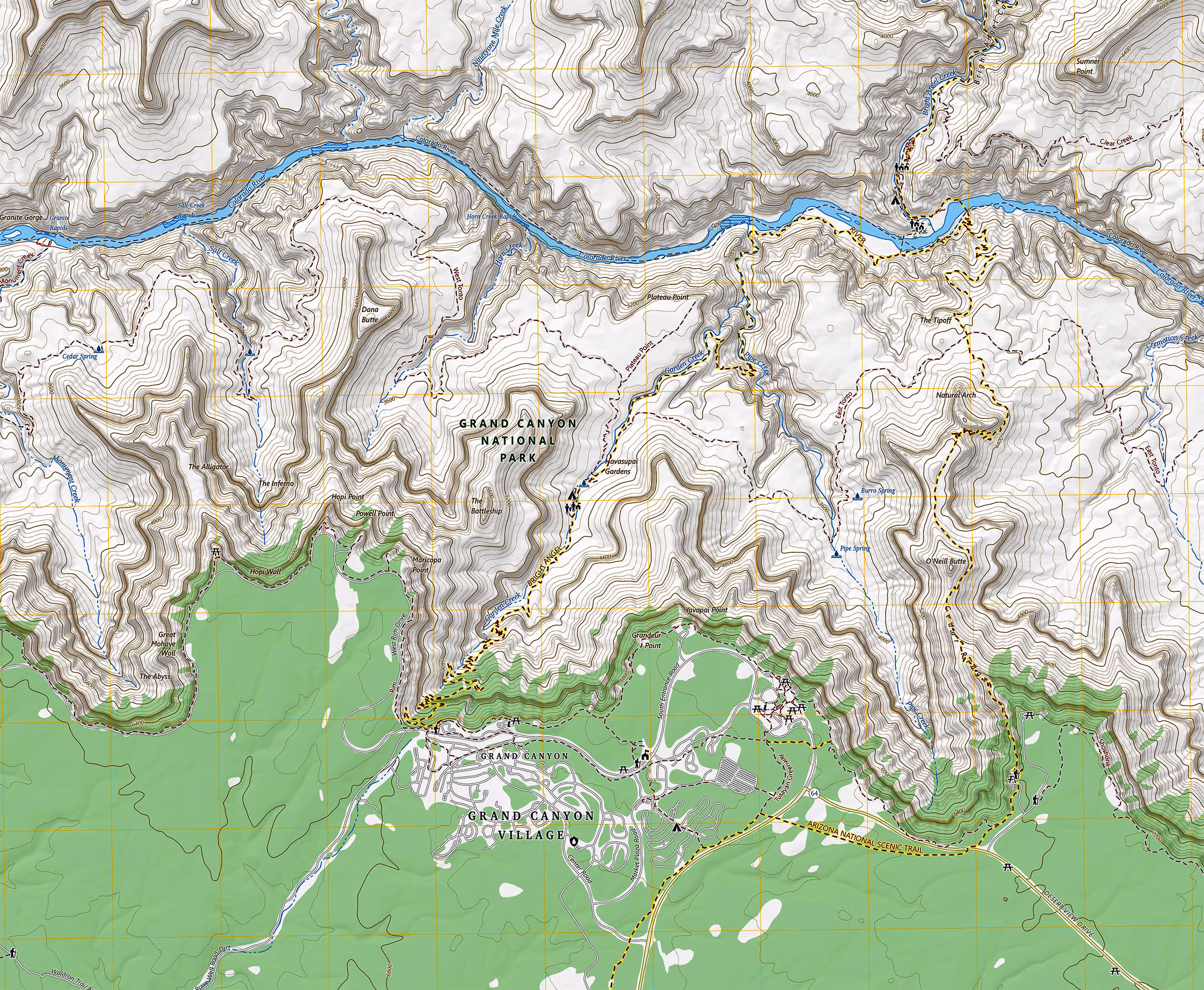
The 25K Recreational Topo series distinguishes itself through several key features that cater directly to the needs of adventurers. Unlike traditional topographic maps that might prioritize geological or scientific data, these new maps put recreational elements front and center. This means trails, rivers, lakes, campgrounds, and various points of interest relevant to outdoor activities are prominently displayed and easily identifiable.
Key benefits and features include:
- Free Accessibility: The most significant advantage is that these maps are available for download without any cost, democratizing access to high-quality mapping data.
- Detailed Scale: Operating at a 1:25,000 scale, these maps offer a granular level of detail, making them ideal for pinpointing specific features and planning routes with precision.
- Recreational Focus: The cartography emphasizes features crucial for outdoor recreation, such as hiking trails, waterways suitable for kayaking or fishing, and designated camping areas.
- Digital Format: Designed for digital use, these maps can be downloaded and utilized on various devices, including smartphones, tablets, and GPS units, allowing for offline navigation in remote areas.
- Customization Options: Users have the flexibility to build and download custom map sections, ensuring they only carry the data relevant to their specific adventure.
Enhancing Safety and Preparedness in the Backcountry
The availability of these detailed, free maps significantly contributes to safety in the backcountry. Proper navigation is a cornerstone of responsible outdoor recreation, and having accurate, up-to-date topographic information can prevent disorientation and emergencies. Hikers can better assess terrain difficulty, identify potential hazards, and plan emergency rendezvous points. For those venturing into areas with limited cell service, the ability to download maps for offline use is a critical safety feature.
Moreover, the maps can aid in environmental stewardship by helping users stick to designated trails and understand the local ecology. By providing clear representations of natural boundaries and protected areas, they encourage responsible interaction with the environment.
How to Access and Utilize the New Maps
Accessing the 25K Recreational Topo series is straightforward. Users can visit the official USGS website, where they will find an intuitive interface for browsing, selecting, and downloading map sections. The process typically involves:
- Navigating to the USGS Map Portal: Locate the dedicated section for the 25K Recreational Topo series.
- Selecting an Area of Interest: Users can pan and zoom on a national map to define their desired region.
- Customizing Map Extent: Tools are provided to draw a custom boundary around the specific area needed.
- Downloading the Map: Once the selection is finalized, the map can be downloaded in a compatible digital format, often PDF or GeoTIFF, suitable for use with various mapping applications.
It is recommended that users familiarize themselves with their chosen mapping application and practice using the downloaded maps before embarking on an adventure, especially in unfamiliar or challenging terrain. Combining these digital maps with traditional navigation skills, such as compass use, remains the gold standard for backcountry safety.
The USGS: A Legacy of Geospatial Information
The U.S. Geological Survey, established in 1879, serves as the nation’s primary civilian mapping agency and a leading provider of natural science information. Its mission encompasses mapping the landscape, understanding natural resources, and monitoring natural hazards. The release of the 25K Recreational Topo series is a continuation of the USGS’s long-standing commitment to public service and the dissemination of critical geospatial data. This initiative leverages modern technology to make complex information more accessible and actionable for a broader audience, reinforcing the agency’s role in supporting both scientific research and public engagement with the natural world.
Key Takeaways
- The USGS has launched a new, free 25K Recreational Topo series of digital maps.
- These maps prioritize recreational features like trails, rivers, and campgrounds.
- They are available for download at no cost, enhancing accessibility for outdoor enthusiasts.
- The 1:25,000 scale provides detailed information for precise navigation.
- Users can customize and download specific map sections for offline use.
- The initiative significantly boosts backcountry safety and trip planning capabilities.
Conclusion
The introduction of the free 25K Recreational Topo series by the USGS represents a significant boon for the outdoor community in 2025. By providing highly detailed, recreation-focused topographic maps at no cost, the agency empowers adventurers with essential tools for safe and informed exploration. This move not only democratizes access to vital geospatial data but also underscores the ongoing evolution of mapping technology in serving public needs. Whether planning a challenging hike, a serene fishing trip, or a family camping excursion, these new maps are set to become an indispensable resource for navigating and appreciating the diverse natural landscapes of the United States.
Originally published: October 18, 2025
Editorial note: Our team reviewed and enhanced this coverage with AI-assisted tools and human editing to add helpful context while preserving verified facts and quotations from the original source.
We encourage you to consult the publisher above for the complete report and to reach out if you spot inaccuracies or compliance concerns.