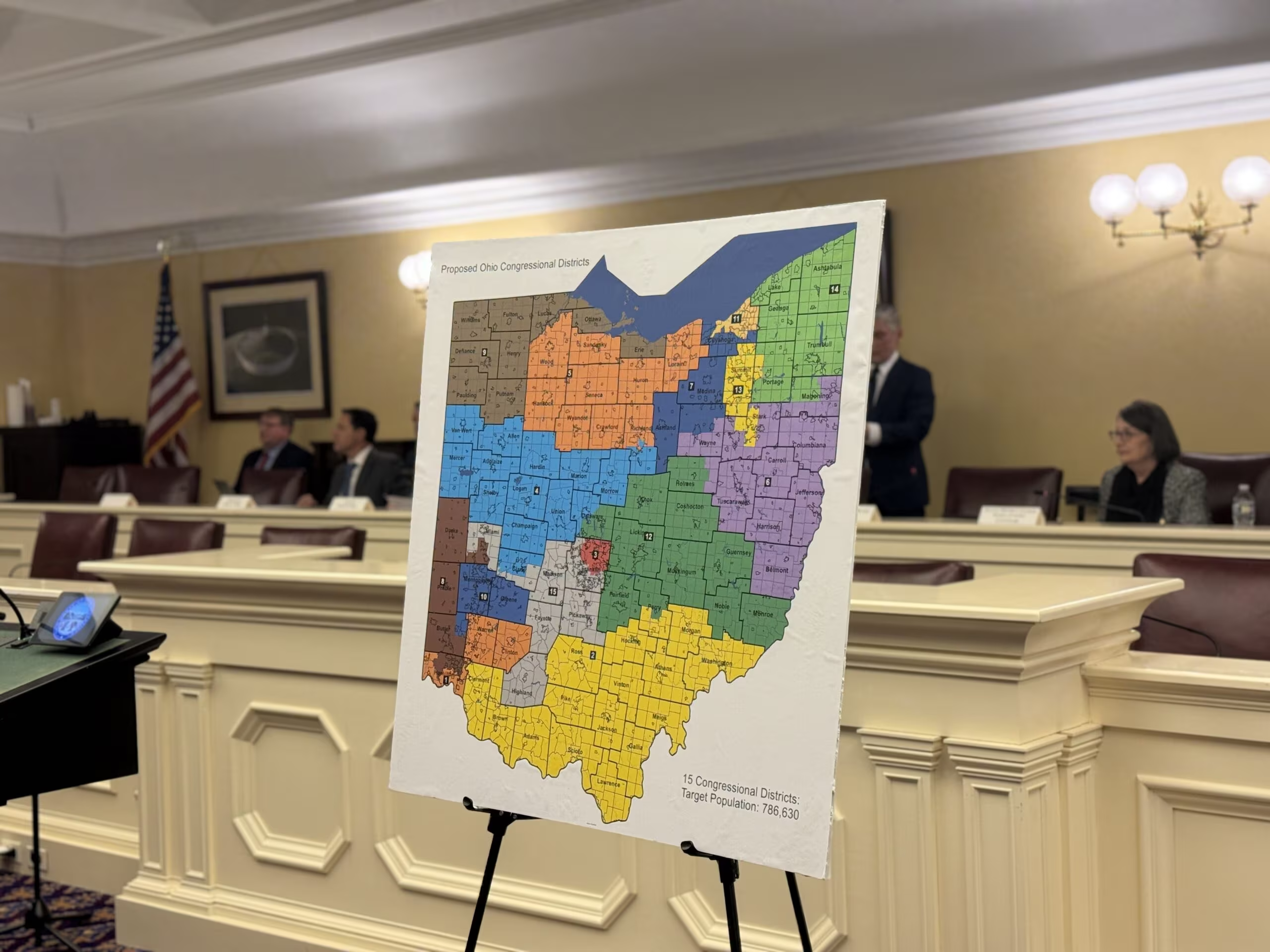
Ohio Adopts Final Congressional Map: Analyzing the Shift in District Lines
The long and legally contentious process of redrawing Ohio’s congressional districts has concluded, resulting in a new map that will define the state’s political landscape for the remainder of the decade. Adopted by the Ohio Redistricting Commission, this final configuration was characterized by leaders from both major parties as a necessary “compromise,” though its primary effect is shifting several traditionally Democratic areas toward a more Republican lean.
For Ohio voters, the new map fundamentally alters who represents them in the U.S. House of Representatives, particularly in and around the state’s major metropolitan centers. This map is now in effect for the 2026 election cycle and beyond, barring further unforeseen legal intervention.

The New Political Calculus: A Projected 10-5 Partisan Split
The core political outcome of the adopted map is a projected 10-5 partisan split in favor of the Republican Party, reflecting the state’s current political leanings. This breakdown represents the division of the state’s 15 congressional seats—Ohio lost one seat following the 2020 Census due to lagging population growth.
The map achieves this partisan advantage primarily by reconfiguring districts that previously favored Democrats, particularly those encompassing urban cores. The strategy employed is often referred to as “cracking and packing”: concentrating Democratic voters into a few districts (packing) while spreading the remaining Democratic voters thinly across surrounding Republican districts (cracking).
Key Changes and Affected Regions
The most significant alterations occurred in the state’s most populous areas, where Democratic votes are concentrated:
- Cleveland and Northeast Ohio: The map significantly redrew the 11th Congressional District, traditionally a Democratic stronghold. While remaining blue, the surrounding districts were adjusted to pull in more Republican voters from suburban and rural areas, concentrating Democratic votes while making neighboring districts safer for the the GOP.
- Columbus and Central Ohio: The 3rd Congressional District (Columbus) remains strongly Democratic, but the surrounding suburban districts, which have seen rapid population growth, were carefully drawn to ensure they remain competitive or lean Republican. This minimizes the potential for Democratic gains from suburban expansion.
- Cincinnati and Southwest Ohio: Similar to the other major cities, the districts here were optimized to maintain Republican control over the majority of the region, despite the Democratic core of Cincinnati.
This configuration is designed to be more legally durable than previous attempts that were struck down by the Ohio Supreme Court for being unconstitutional partisan gerrymanders.
The Anatomy of the “Compromise”
The adoption of this map marks the culmination of years of legal battles and political maneuvering following the 2020 Census. The process was fraught with tension, as previous maps drawn solely by Republican majorities were repeatedly invalidated by the state’s highest court for violating anti-gerrymandering provisions in the state constitution.
The map ultimately approved was the result of negotiations within the Ohio Redistricting Commission, a body composed of elected state officials, including the Governor, State Auditor, Secretary of State, and members appointed by the leadership of the General Assembly.
“This map represents a necessary step forward for the state,” stated one official involved in the negotiations. “While neither side received everything they asked for, it provides the stability needed for upcoming elections and respects the legal parameters set by the Ohio Supreme Court.”
The term “compromise” in this context refers less to an equal division of power and more to the agreement to adopt a map that, while still heavily favoring Republicans, was deemed less egregious than prior attempts and stood a better chance of surviving judicial review. For Democrats, accepting the 10-5 split prevented the possibility of an even more heavily skewed map being imposed later, ensuring five safe Democratic seats.

Implications for Voters and Future Elections
With the map finalized, the focus shifts to the upcoming election cycles, starting with the 2026 midterms. The new boundaries have several practical implications for Ohio voters:
- New Representatives: Many voters will find themselves in a new congressional district, meaning they will be represented by a new member of Congress or will be voting in a different primary race than in previous years.
- Reduced Competition: The highly partisan nature of the districts means that most general elections will be decided during the primary phase. In a district drawn to be 70% Republican, the Democratic candidate has virtually no chance, and vice versa. This often leads to more extreme candidates winning, as they only need to appeal to the most dedicated members of their party.
- Increased Stability: After years of legal uncertainty, the adoption of a map that is expected to hold up in court provides much-needed stability for candidates, parties, and election officials preparing for future cycles.
Ohio’s redistricting saga highlights the intense national battle over how political power is allocated at the state level, demonstrating how map drawing can lock in partisan advantages for a decade.
Key Takeaways
- New Map Adopted: The Ohio Redistricting Commission finalized the state’s congressional map after years of legal challenges.
- Partisan Split: The map is projected to result in a 10 Republican to 5 Democratic split in Ohio’s 15 U.S. House seats.
- Compromise Definition: The map was called a “compromise” because it was agreed upon by both major parties, providing stability and ensuring five safe Democratic seats, despite the overall Republican advantage.
- Voter Impact: Voters in major metropolitan areas (Cleveland, Columbus, Cincinnati) will see significant changes to their district boundaries and likely their representatives.
- Future Elections: The new lines are now set for the 2026 election cycle, reducing general election competition in most districts.
Conclusion
The adoption of Ohio’s new congressional map resolves a period of significant political and legal turmoil. While the map provides electoral stability, it solidifies a substantial partisan advantage for Republicans, ensuring that the state’s representation in Washington D.C. will lean heavily to the right for the foreseeable future. Voters are strongly encouraged to verify their new district numbers and representatives ahead of the next primary election to understand how these boundaries directly affect their representation.

Original author: Morgan Trau
Originally published: October 31, 2025
Editorial note: Our team reviewed and enhanced this coverage with AI-assisted tools and human editing to add helpful context while preserving verified facts and quotations from the original source.
We encourage you to consult the publisher above for the complete report and to reach out if you spot inaccuracies or compliance concerns.