The Immediate Aftermath: Assessing the Scale of Destruction in Jamaica
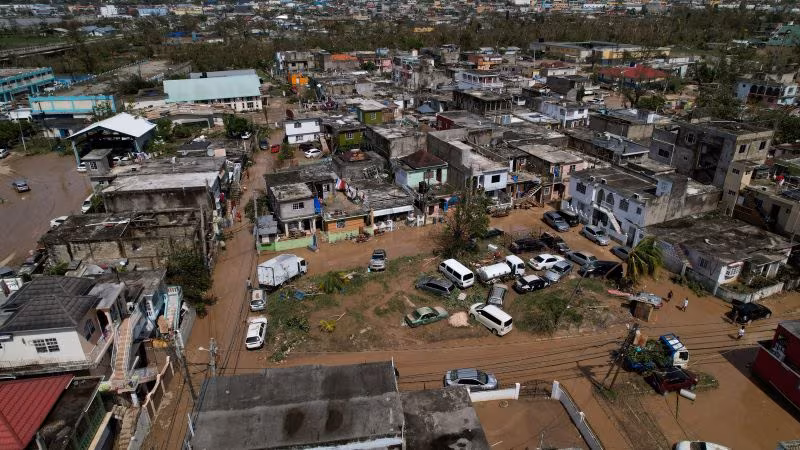
The full, devastating scope of Hurricane Melissa’s impact on Jamaica is now visible, confirmed by high-resolution satellite imagery released by the imaging firm Vantor. The Category 4 storm, which made landfall on Tuesday, October 28, 2025, has left a trail of destruction across the island nation, fundamentally altering the landscape of major coastal towns and critical infrastructure.
Initial reports from ground teams, hampered by widespread flooding and impassable roads, suggested severe damage. However, the new aerial perspective provides irrefutable evidence of a catastrophic event, highlighting the vulnerability of the Caribbean infrastructure to intense tropical cyclones.
The images confirm that the storm surge and sustained 140 mph winds stripped roofs from homes, flattened entire communities, and caused massive coastal erosion. This event is already being compared to some of the most destructive storms in Jamaica’s history, including Hurricane Gilbert in 1988, underscoring the severity of Melissa’s impact.
Satellite Evidence: Vantor Imagery Reveals Critical Infrastructure Collapse
The satellite data obtained from Vantor is crucial for disaster response teams, offering the first comprehensive, objective assessment of the damage zones. By comparing pre-storm imagery with the post-landfall views, analysts can pinpoint areas requiring immediate humanitarian aid and prioritize restoration efforts.
Key Findings from the Aerial Assessment:
- Widespread Structural Failure: In coastal parishes like Portland and St. Thomas, the images show that up to 70% of non-reinforced structures suffered major damage or complete collapse, particularly in low-lying residential areas.
- Agricultural Ruin: Vast tracts of agricultural land, essential for the Jamaican economy, appear completely submerged or stripped bare. Banana, coffee, and sugar cane plantations, which form the backbone of rural livelihoods, are severely impacted.
- Transportation Gridlock: Major arterial roads, including sections of the A1 and A4 highways, are visibly blocked by landslides, debris, and extensive flooding. This severely complicates the delivery of emergency supplies and medical assistance.

The Challenge of Storm Surge and Flooding
One of the most destructive elements captured in the Vantor images is the extent of the inland flooding caused by the massive storm surge. The surge, estimated to be 15 to 20 feet in some areas, pushed seawater miles inland, contaminating fresh water sources and rendering many ground-floor homes uninhabitable.
“The sheer volume of water displacement is staggering. What the satellite images reveal is not just wind damage, but the profound, long-term contamination of vital resources and the complete obliteration of coastal ecosystems,” stated Dr. Elena Rodriguez, a disaster risk analyst working with the Caribbean Disaster Emergency Management Agency (CDEMA).
The Humanitarian Crisis and Initial Response Efforts
The immediate consequence of the devastation is a rapidly escalating humanitarian crisis. Thousands of residents are displaced, seeking shelter in government-run facilities, many of which are themselves operating under strained conditions due to power outages and limited resources.
Critical Needs Identified:
- Water and Sanitation: Contaminated water sources pose the immediate threat of waterborne diseases. The priority is distributing clean drinking water and establishing temporary sanitation facilities.
- Shelter and Food: With homes destroyed, temporary shelter materials and non-perishable food items are urgently required for the estimated 50,000 people displaced.
- Medical Aid: Hospitals and clinics, many of which sustained damage, are overwhelmed with trauma cases and injuries related to the storm and subsequent cleanup efforts.
The Jamaican Defence Force (JDF) has mobilized all available units for search and rescue operations, focusing on isolated communities cut off by flooding and landslides. International assistance is already underway, with the United States Agency for International Development (USAID) and the United Nations Office for the Coordination of Humanitarian Affairs (OCHA) coordinating shipments of essential supplies.

Long-Term Recovery and Economic Implications
Hurricane Melissa’s impact will reverberate through the Jamaican economy for years. The island relies heavily on tourism and agriculture, sectors that have been severely compromised.
Economic Fallout:
- Tourism Infrastructure: Many hotels and resorts along the northern coast sustained significant damage, leading to immediate cancellations and a projected sharp decline in revenue for the upcoming high season.
- Rebuilding Costs: Preliminary estimates suggest the cost of rebuilding infrastructure—roads, power grids, communication lines, and public housing—will run into the billions of U.S. dollars, placing immense strain on the national budget.
- Insurance Challenges: The scale of the disaster is expected to test the capacity of regional insurance markets, potentially leading to delays in payouts and further complicating individual recovery efforts.
This event also serves as a stark reminder of the increasing intensity of tropical storms, a trend that climate scientists link to rising sea surface temperatures. For island nations like Jamaica, adapting infrastructure to withstand future, more powerful storms is no longer a long-term goal but an immediate necessity.
Key Takeaways and Next Steps
As the immediate crisis transitions into a long-term recovery effort, the focus shifts from rescue to resilience. The images from Vantor have provided the necessary clarity to drive effective, targeted aid.
- Severity Confirmed: Hurricane Melissa caused catastrophic, widespread damage, particularly to coastal infrastructure and agricultural sectors.
- Humanitarian Priority: Immediate efforts are concentrated on providing clean water, temporary shelter, and medical support to the tens of thousands displaced.
- Economic Setback: The storm represents a major economic blow, impacting tourism and requiring billions in international and domestic investment for reconstruction.
- Future Resilience: The event underscores the urgent need for climate-resilient building codes and enhanced disaster preparedness across the Caribbean region.
Conclusion
The devastation wrought by Hurricane Melissa is a profound challenge for Jamaica, demanding a coordinated and sustained global response. While the photographs confirm the worst fears regarding the storm’s power, they also serve as a vital tool for directing resources where they are most needed. The recovery process will be lengthy and arduous, requiring not just immediate aid, but strategic investment to ensure that Jamaica can rebuild stronger and more resilient against the inevitable threats of future tropical cyclones.
What’s Next
Over the coming weeks, the focus will shift to clearing debris and restoring essential services. Engineers and utility crews are working around the clock to re-establish the power grid, a process expected to take several months in the hardest-hit areas. The international community is preparing a major donor conference to secure the necessary funds for the multi-year reconstruction phase, emphasizing sustainable and climate-proof infrastructure development.
Original author: Avery Schmitz
Originally published: October 30, 2025
Editorial note: Our team reviewed and enhanced this coverage with AI-assisted tools and human editing to add helpful context while preserving verified facts and quotations from the original source.
We encourage you to consult the publisher above for the complete report and to reach out if you spot inaccuracies or compliance concerns.