Winter Storm Warning Remains Active Across Chicago and Northwest Indiana
Residents across the Chicago metropolitan area and Northwest Indiana woke up to treacherous conditions this Monday morning as an unseasonable and powerful snowstorm, heavily amplified by lake-effect dynamics, continues to impact the region. A Winter Storm Warning remains in effect for several key counties, urging commuters and residents to exercise extreme caution or avoid travel altogether.
The storm, which began late Sunday, delivered highly localized and intense snowfall, a signature characteristic of lake-effect events. While the exact timing for the warning’s expiration varies by county, most areas are expected to see the heaviest snow bands diminish by Monday evening, though hazardous travel conditions will persist well into Tuesday morning.

Accumulation Totals and Affected Areas
The most significant impact is being felt in downwind areas immediately adjacent to Lake Michigan, where moisture and temperature differentials created persistent, heavy snow bands. This phenomenon has led to stark variations in accumulation, with some neighborhoods reporting only minor dusting while others are buried under nearly a foot of snow.
Official reports indicate that localized totals in the heaviest bands could reach between 6 and 12 inches. The areas under the most severe warning include:
- Illinois: Northeastern Cook County, Lake County, and portions of DuPage County.
- Indiana: Lake County and Porter County, where the heaviest and most persistent snow bands have been observed.
These totals are highly dependent on the precise movement of the snow bands, which can shift rapidly, causing whiteout conditions and sudden drops in visibility.
Understanding the Lake-Effect Phenomenon
This event is a classic example of lake-effect snow, a meteorological process that occurs when cold air masses move across large, relatively warmer bodies of water, such as Lake Michigan. As the frigid air flows over the warmer water, it picks up moisture and heat. This air mass then rises, cools, and condenses, forming narrow but intense bands of precipitation that dump massive amounts of snow quickly over specific downwind areas.
Crucially, the strength and location of these bands are determined by wind direction. During this storm, persistent northerly and northeasterly winds have channeled the heaviest snow directly over the southern and southeastern shores of the lake, explaining the high totals in Northwest Indiana and the immediate Chicago lakefront.
Travel Disruptions and Safety Guidance
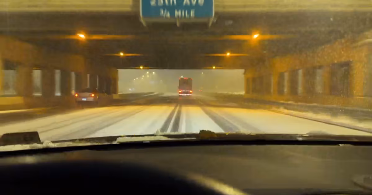
The combination of heavy, wet snow and strong winds—which have gusted up to 30 miles per hour—has made travel exceptionally difficult and dangerous. Authorities are strongly advising against non-essential travel in the warning areas.
Road Conditions and Public Transit
State and local transportation departments are struggling to keep pace with the rapid accumulation. Roads are slick, and visibility has been reduced to near-zero at times, creating whiteout conditions particularly on elevated expressways and near the lake.
- Interstate Travel: Major routes, including I-94 and I-80/94 in Northwest Indiana, are experiencing significant delays and multiple spin-outs. Drivers should increase following distances dramatically and reduce speeds.
- Public Transportation: While the CTA and Metra systems are operational, delays are widespread due to switch issues, reduced visibility for operators, and slow travel times. Commuters should check service alerts frequently before heading out.
- Air Travel: O’Hare International Airport (ORD) and Midway International Airport (MDW) are reporting numerous delays and cancellations. Travelers should confirm flight status directly with their airline.

Essential Safety Measures
Given the severity of the storm, public safety officials have issued specific warnings, emphasizing preparedness and caution:
“If you must travel, ensure your vehicle is fully fueled, and carry an emergency kit including blankets, water, and non-perishable food. The risk of being stranded due to accidents or road closures is significantly elevated during these intense snow bands.”
Key Safety Reminders:
- Avoid Driving: If your travel is not essential, stay home. Remote work is highly encouraged.
- Clear Exhaust Pipes: If stuck in snow, ensure your vehicle’s exhaust pipe is clear to prevent deadly carbon monoxide poisoning.
- Check on Neighbors: Ensure elderly or vulnerable neighbors have adequate heat and supplies.
- Power Outages: Be prepared for potential power outages caused by heavy snow weighing down power lines. Have flashlights and battery backups ready.
Unseasonable Timing and Climate Context
This storm is particularly notable for its timing. While the Chicago area is accustomed to heavy winter snowfall, a storm of this magnitude occurring during the late fall season is considered unseasonable. This early and intense cold snap, combined with the still-relatively-warm waters of Lake Michigan, created the perfect recipe for extreme lake-effect snow.
Meteorologists note that while lake-effect snow is common, the intensity and duration seen this Monday are more typical of mid-winter events, underscoring the severity of the current conditions.
Key Takeaways for Residents
For those in the affected regions, here are the critical points to remember as the storm continues:
- Warning Status: The Winter Storm Warning is active until Monday evening for most of the Chicago metro and Northwest Indiana.
- Accumulation: Expect highly variable totals, with localized areas receiving 6 to 12 inches.
- Travel: Non-essential travel is strongly discouraged due to whiteout conditions and slick roads.
- Safety: Prioritize safety by carrying emergency supplies if driving and being prepared for potential power disruptions.
- Timeline: Conditions are expected to slowly improve after Monday evening, but residual ice and snow will make Tuesday morning’s commute challenging.

What’s Next: The Forecast Ahead
Forecasters anticipate a gradual transition from heavy snow to lighter flurries and eventually cold, clear conditions as the system moves east and the wind shifts. The immediate concern remains the Monday afternoon commute, which is projected to be the most hazardous period of the day.
Temperatures are expected to remain well below freezing, ensuring that the accumulated snow will not melt quickly. This means that cleanup efforts and residual travel impacts will continue through the middle of the week. Residents should monitor local weather alerts closely for any adjustments to the warning status or specific localized advisories.
Original author: Mary Kay Kleist, Darius Johnson, Laura Bannon, Kris Habermehl, Albert Ramon, Kylee Miller
Originally published: November 10, 2025
Editorial note: Our team reviewed and enhanced this coverage with AI-assisted tools and human editing to add helpful context while preserving verified facts and quotations from the original source.
We encourage you to consult the publisher above for the complete report and to reach out if you spot inaccuracies or compliance concerns.